What a year 2013 has been. We ended the year with news that Geoporter received official recognition from the U.S. Federal Government for our Non-Profit Status. That means we are officially a non-profit or a 501(C)3. This status is retroactive back to November 12, 2012. This is exciting news as we move Geoporter forward, making a difference in communities through education and maps.
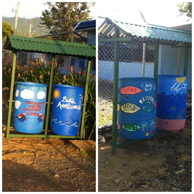
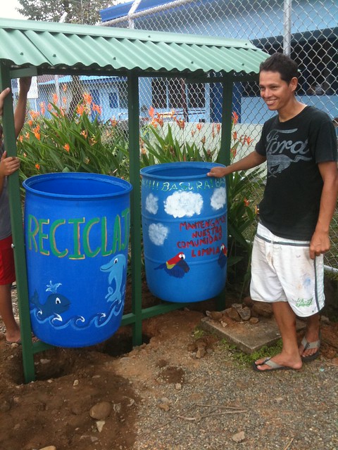
This vast world we live in is filled with beauty in the smallest of corners. All one has to do is take a look at the recent community trash and recycling containers that were built and installed in Bahía Ballena. The first two containers were placed at two different sites where trash is found almost every day: next to the school entrance and between the soccer field and other entrance to the school.
These trashcans are simply amazing!! How can the colorful containers not draw your eyes to look? One person’s trash is another person’s treasure, or in this case piece of art.
A bit of background
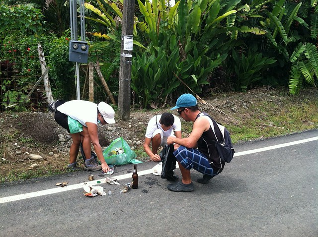
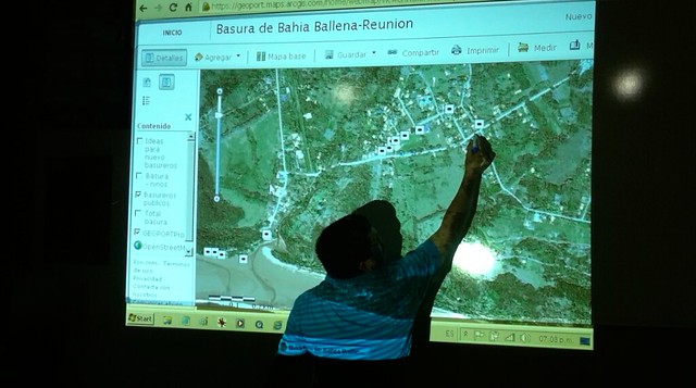
This project started several years ago with residents of Bahía Ballena noticing the amount of trash spread throughout their community. Wanting to do something about it, they started doing community trash cleanups. Over time the trash cleanup involved into trash mapping, using GPS to map the trash they would pick up in the streets and on the beaches.
The thing about using GPS and GIS, is that we can analyze the data about the trash……and then do something about it.
Time for Action!
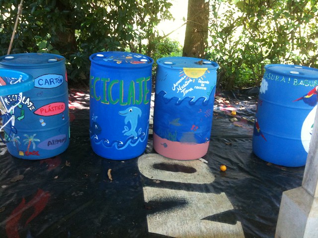
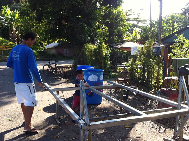
In December, when the tourist season was a little on the lighter side, residents met to review the trash mapped and identify where they thought public trash cans should be placed. For a town of approximately 1,000 residents and more tourists than cars, only 12 public trashcans existed. After the 3 meetings, they decided where 13 new trashcans needed to be placed. But these wouldn’t be just any special trashcans. These new trashcans would actually hold two containers: one for trash and the other for recycling.
Ronald took the lead in constructing the frame and roof for the new containers with the help of a local repair shop for tools and welding equipment. Thanks to a group of students and some help of local students, 4 recycled blue bins were painted to serve as the new containers for the two sites.
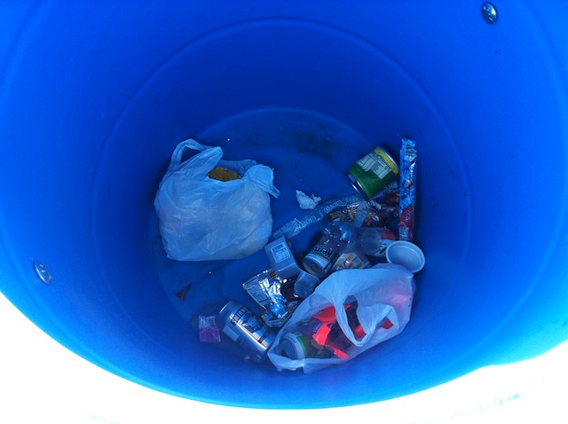
A few days after the first trashcan was installed next to the school, I returned to find trash in the container!!
Only time will tell if these incredible containers will draw people’s attention and encourage them to place their trash in the containers. As the project moves forward, the community is looking for tour companies, restaurants, hotels, and other businesses to purchase the materials for the containers. Bahía Aventuras and Bodhi Surf sponsored the materials for the first two basureros sites. If you are interested in donating to the construction of a trash can, let us know.
Only time will tell if these incredible containers will draw people’s attention and encourage them to place their trash in the containers. But one thing’s for sure, when classes start up in a few days, the students will have a place to put their trash.
One of the objectives of the Geoporter project is to share our knowledge of geospatial technologies, GIS, GPS and remote sensing, with others. But ultimately what we hope to achieve is that by sharing our knowledge with others, others will acquire the skills to not only use GPS they will have the skills and knowledge to share what they’ve learned with others. And so the sharing begins….
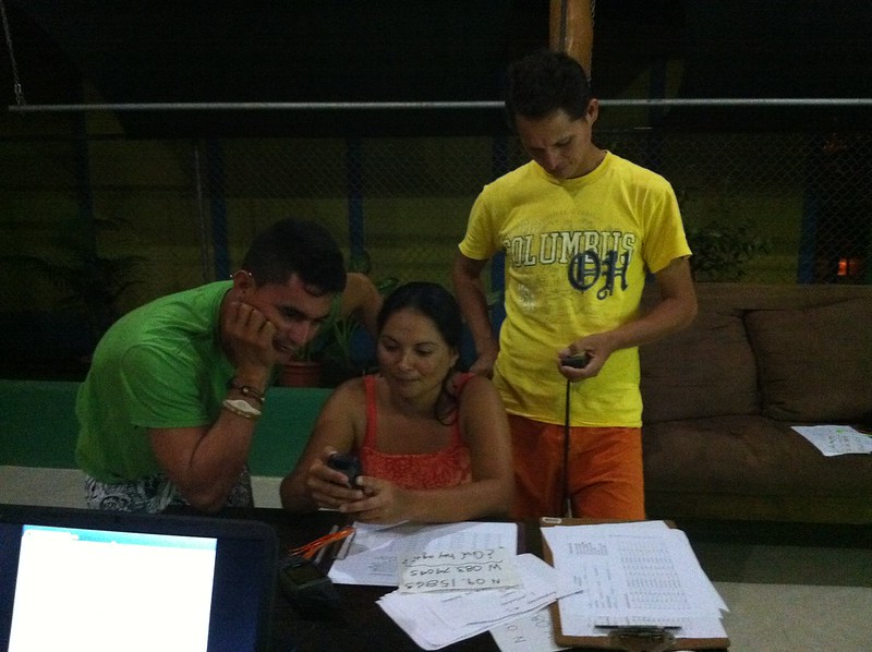
Every week, we have weekly meetings with the tour guides to learn more about GPS, how to use the data collection sheet that was developed in conjunction with the tour guides and Fundacion KETO, and transfer the data to the computers to map it. Recently new guides have started to attend the trainings, and others already using GPS have started sharing what they know with those who are new.
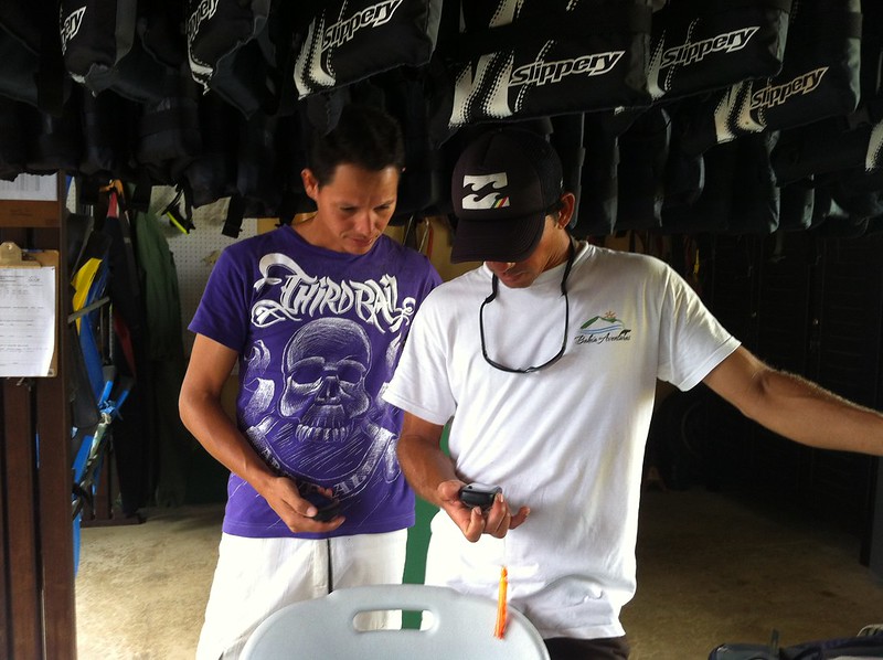
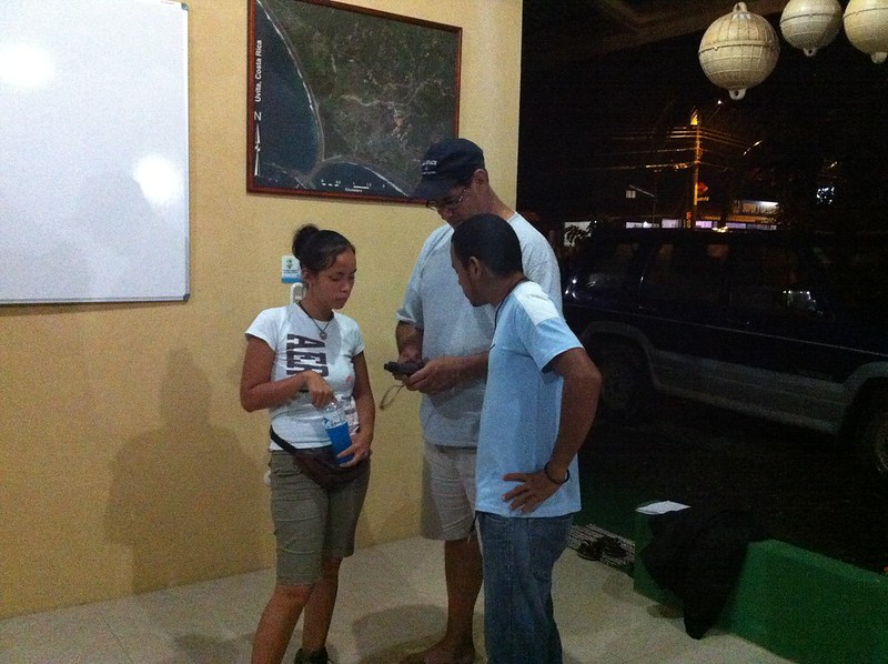
The first week in December, the president of the Asociacion de Guias de Bahia Ballena (ASOGUIBA) and one of the key partners in the Ballenas project, Fernando Guerrero invited the president and treasurer from the Asociacion Guias Turisticas Piedras Blancas, in Piedras Blancas National Park. Bruss and Rocio came to our evening meeting where Fernando explained GPS to them and had them practice using GPS in the street. Ronald explained the project and showed how they are using ArcGIS Online to record whale sightings in Marino Ballena National Park and the trash map that is being used to assess the location of new public trash cans.
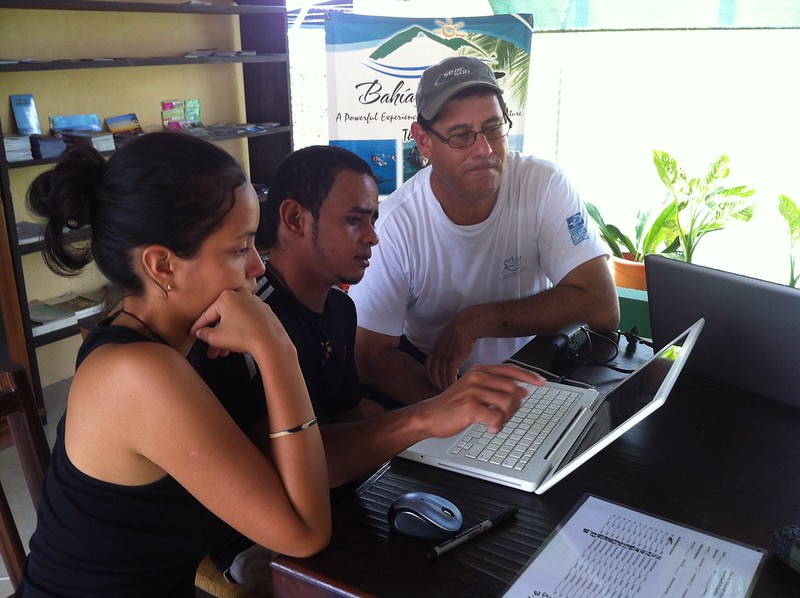
The following day, Bruss and Rocio explored a bit of Bahia Ballena with Luz and Fernando using GPS units from the project. They then returned to Bahia Aventuras to download their points and create their own map. They were excited to see the result and were discussing ideas they would like to explore in Piedres Blancas and how to recieve additional training using GPS and GIS.
It was wonderful to see the sharing of knowledge of using GPS to collect data points and then transferring them on a map. And what’s better is that the residents of Bahia Ballena were teaching others. I think a transition has begun…
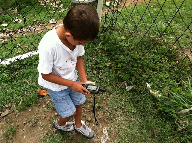
As mentioned earlier, one of the projects I’ll be working on while I’m here Uvita – Bahia Ballena is mapping the basura (trash). The first day I arrived, I wanted to get to know my way around town a little better. I figured what better way to get to know the town than to walk around while also getting a closer look at one of the projects I’ll be working on. I could have ventured by myself, but then what fun would that be. Maria Paula was out of school for the week (think more like a spring break for students in the U.S). so she came with me. For this first venture, we walked through town and then along la playa Chaman. For this adventure we took two GPS’s. We found several other items of interest besides trash.
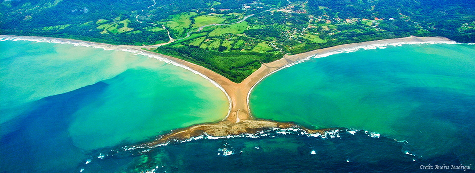
On our next outing the following day, Maria Paula and I stopped to pick up her friend and classmate Suhel. This time we had 3 GPS’s and a plastic bag to collect trash in. When we reached the park entrance, the park rangers let us in without having to pay the $6 that’s typically required to access the Marino Ballena National Park. We ventured in the opposite direction towards the Tombolo, or the part of the beach that look’s like a whale’s tale. This tombolo is a natural formation.
Shortly after we ventured down the beach, we realized that the bag we brought with us to collect the trash was too small. We made too and eventually wound us using our hands to take the trash out with us. It’s amazing the type of basura you’ll find on the beach. These are some of the most beautiful beaches I’ve seen. So where does this trash come from that ends up on the beach? Well that’s one of the questions we hope that using GPS and GIS will help us to understand.
We had our first GPS and GIS training of the week at Escuela Verde. While the students were on their two week break, a few of the teachers came back to school to see what GPS is all about and get some ideas on how they can use it in their classes. Escuela Verde is a bilingual school, offering classes in both Spanish and English for students in K-6. Some teachers were very comfortable in English, while others were native Spanish speakers with limited English. But when teaching others to use GIS and GPS, its seems that it has its own language that is universal.
We started off with an overview of ArcGIS.com, demonstrating how to access a variety of basemaps and other data hosted online. One teacher, David, picked up on using the ArcGIS online immediately and had set up an account and was on his way just after the overview. It was so great to see him and the others dive right in. After some exploring on the computers we stepped outside to use the GPS units.
The best way to learn how to use a GPS unit, start using the unit as you walk around the school building looking at your track and collecting waypoints. There are also several great activities that explore latitude and longitude, as well as finding your location from the Going Places with GPS book.
Over the next month, the teachers have been asked to explore some more with the online GIS and the GPS units so that when I’m back in August I can help them answer any questions they might have as well as help them with their ideas on integrating both into their teaching.
A brief stroll down the newly paved road in Bahia Ballena took us to the entrance of Parque Nacional Marino Ballena. Stopping to pick up towels along the way, we were all set to head to the beach. I must say, it was simply amazing. The water was like bath water, the backdrop of the beach were palms and forest, and blue sky’s were plentiful.
After some time at the beach, we made our way back to our hotel, La Fiore de Bahia, to cut up some piña, and make guacamole. This afternoon we met with a few people, Travis, Rafa, Ronald, y Ray, who we will be working with this time and when I come back in August. We also planned out our itinerary for the week which includes a visit to Escuela Verde to do some GPS training with the teachers, going out on a boat tour with Rafa from Bahia Aventures to get a better understanding of the whale monitoring the tour boat operators wish to do, a meeting with a few of the local boat tour guides, meeting with the KETO foundation to see what program they are working for monitoring whales, and a few other activities before we head back to San Jose Thursday.
 What a year 2013 has been. We ended the year with news that Geoporter received official recognition from the U.S. Federal Government for our Non-Profit Status. That means we are officially a non-profit or a 501(C)3. This status is retroactive back to November 12, 2012. This is exciting news as we move Geoporter forward, making a difference in communities through education and maps.