Basura de Bahia Ballena
Reply
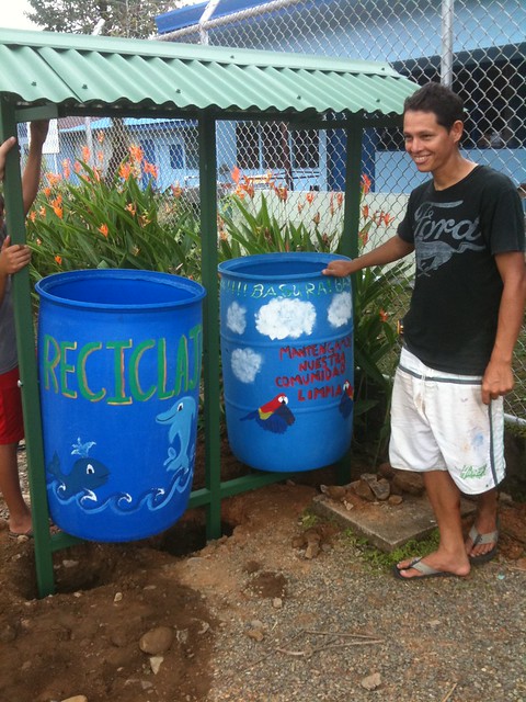
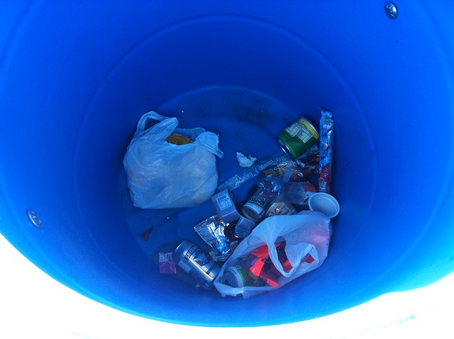
This vast world we live in is filled with beauty in the smallest of corners. All one has to do is take a look at the recent community trash and recycling containers that were built and installed in Bahía Ballena. The first two containers were placed at two different sites where trash is found almost every day: next to the school entrance and between the soccer field and other entrance to the school.
These trashcans are simply amazing!! How can the colorful containers not draw your eyes to look? One person’s trash is another person’s treasure, or in this case piece of art.
A bit of background
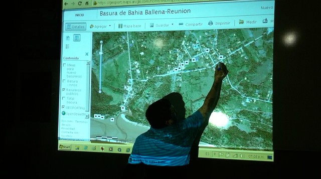
This project started several years ago with residents of Bahía Ballena noticing the amount of trash spread throughout their community. Wanting to do something about it, they started doing community trash cleanups. Over time the trash cleanup involved into trash mapping, using GPS to map the trash they would pick up in the streets and on the beaches.
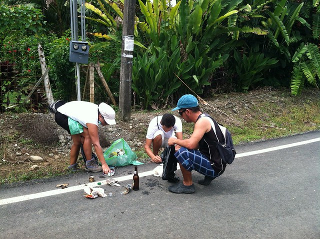
With adults and students partaking in mapping the trash, little by little they started to see the problem areas. While doing trash cleanups is a great service project, life can’t be about setting dates and times to pick up trash. And as our friends at Bodhi Surf put it “trash cleanups are not a sexy service project (luckily we can do them at the beach which makes it a little better)”.
The thing about using GPS and GIS, is that we can analyze the data about the trash……and then do something about it.
Time for Action!
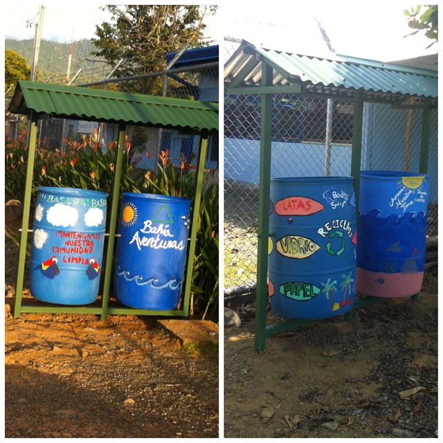
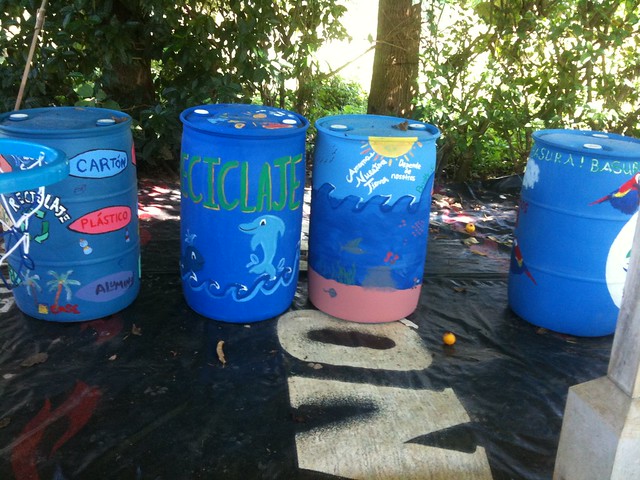
In December, when the tourist season was a little on the lighter side, residents met to review the trash mapped and identify where they thought public trash cans should be placed. For a town of approximately 1,000 residents and more tourists than cars, only 12 public trashcans existed. After the 3 meetings, they decided where 13 new trashcans needed to be placed. But these wouldn’t be just any special trashcans. These new trashcans would actually hold two containers: one for trash and the other for recycling.
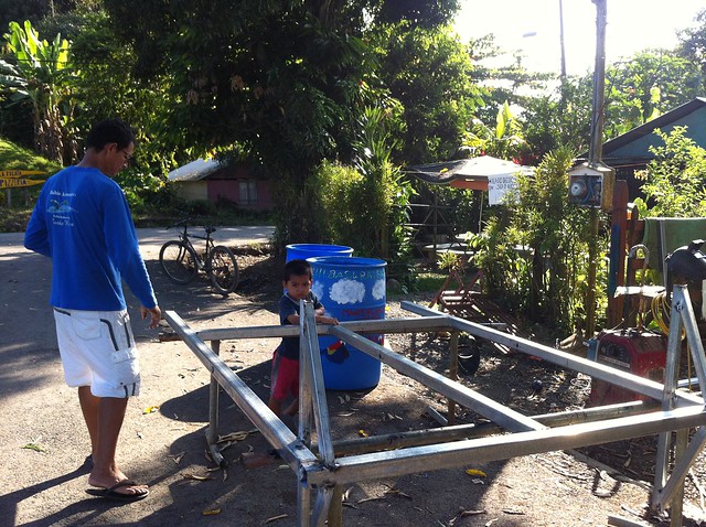
Ronald took the lead in constructing the frame and roof for the new containers with the help of a local repair shop for tools and welding equipment. Thanks to a group of students and some help of local students, 4 recycled blue bins were painted to serve as the new containers for the two sites.
A few days after the first trashcan was installed next to the school, I returned to find trash in the container!!
Only time will tell if these incredible containers will draw people’s attention and encourage them to place their trash in the containers. As the project moves forward, the community is looking for tour companies, restaurants, hotels, and other businesses to purchase the materials for the containers. Bahía Aventuras and Bodhi Surf sponsored the materials for the first two basureros sites. If you are interested in donating to the construction of a trash can, let us know.
Only time will tell if these incredible containers will draw people’s attention and encourage them to place their trash in the containers. But one thing’s for sure, when classes start up in a few days, the students will have a place to put their trash.
One of the objectives of the Geoporter project is to share our knowledge of geospatial technologies, GIS, GPS and remote sensing, with others. But ultimately what we hope to achieve is that by sharing our knowledge with others, others will acquire the skills to not only use GPS they will have the skills and knowledge to share what they’ve learned with others. And so the sharing begins….
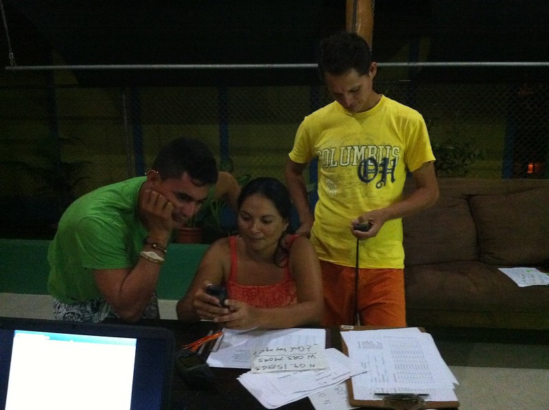
Every week, we have weekly meetings with the tour guides to learn more about GPS, how to use the data collection sheet that was developed in conjunction with the tour guides and Fundacion KETO, and transfer the data to the computers to map it. Recently new guides have started to attend the trainings, and others already using GPS have started sharing what they know with those who are new.
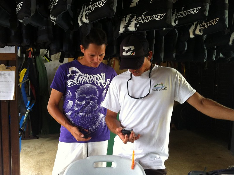
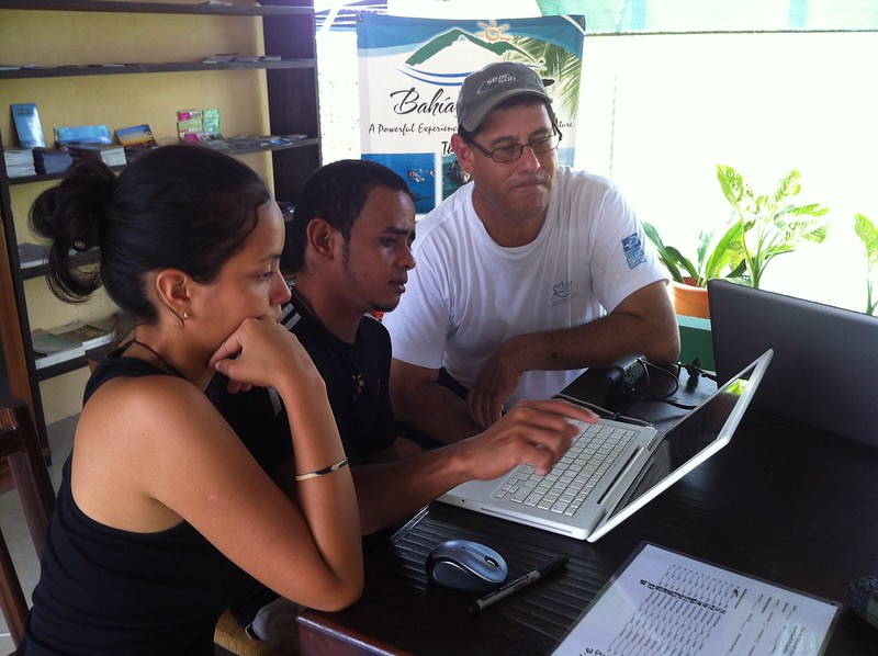
The first week in December, the president of the Asociacion de Guias de Bahia Ballena (ASOGUIBA) and one of the key partners in the Ballenas project, Fernando Guerrero invited the president and treasurer from the Asociacion Guias Turisticas Piedras Blancas, in Piedras Blancas National Park. Bruss and Rocio came to our evening meeting where Fernando explained GPS to them and had them practice using GPS in the street. Ronald explained the project and showed how they are using ArcGIS Online to record whale sightings in Marino Ballena National Park and the trash map that is being used to assess the location of new public trash cans.
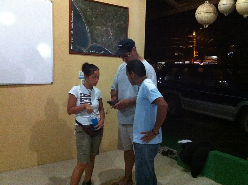
The following day, Bruss and Rocio explored a bit of Bahia Ballena with Luz and Fernando using GPS units from the project. They then returned to Bahia Aventuras to download their points and create their own map. They were excited to see the result and were discussing ideas they would like to explore in Piedres Blancas and how to recieve additional training using GPS and GIS.
It was wonderful to see the sharing of knowledge of using GPS to collect data points and then transferring them on a map. And what’s better is that the residents of Bahia Ballena were teaching others. I think a transition has begun…
As the New Year begins, so too does a new school year for students in Costa Rica. Unlike the U.S. where summer vacation occurs during the months of June through August, students in Costa Rica graduate in December and go back to school in February.
At Escuela Verde, the teachers decided to spend some of their final summer days not only setting up their rooms and preparing for classes, but also wanting to learn more about what they can do with GPS and GIS with their students. During the school year last year, students were using GPS to record wildlife at a nearby wildlife refuge, conduct mathematical geocaching activities, observe rock and soil types, and explore plate tectonics.

Wednesday was the first of three training sessions for the teachers. With limited internet access at time at Escuela Verde, the training used book 2 from the Mapping Our World Series to learn the basics of ArcGIS Desktop. Joining us was Esteban, the new 5/6 grade Spanish speaking science teacher. Remember, Escuela Verde is a bi-lingual school with classes at every grade level being taught in English and Spanish by different teachers. Even with the lessons from Mapping Our World in English, the Spanish speaking teachers were able to explore an activity that can be used in their classroom.
Today was the second training and rather than meeting from 9-12, we decided as a group to meet at 7:30am so that we can get a start on heading out into the field to learn to use GPS. But to start any day off right, one needs a good cup of Costa Rican coffee.
We stayed on school grounds today as we had to modify our original plan to go to Playa Arco to collect due to another meeting the teachers had to attend. After collecting some points about features on the property, we returned to the library to setup the computers and then download the points onto ArcGIS Desktop. We’re using ArcGIS Desktop rather than ArcGIS Online due to the limited internet connection that exists at school. Even while stepping through downloading points, the electricity went out for 10 minutes.
Next Tuesday, we’ll meet for the final time before classes start so that the teachers can explore more activities with ArcGIS Desktop, create a map of Costa Rica, and develop and modify activities to use in their classes, which start Wednesday. This should be an exciting year to see the various activities and projects the teachers will do with their students.
Teachers at one primary school in Costa Rica are changing students’ lives while having access to limited resources that one would think are essential for conducting geospatial investigations. Escuela Verde is a bi-lingual primary school located in Uvita – Bahia Ballena in the Osa Region on the southern Pacific Coast. During two months this summer, four teachers at Escuela Verde worked with the Geoporter program to learn how to use GIS and GPS in their classrooms.
With teachers having both excitement and hesitation of venturing into learning how to use GIS and GPS, the experience wasn’t without a few bumps. After the first week learning how to use GIS and GPS, Escuela Verde had the unfortunate experience of having the copper lines for their electricity stolen. Without electricity for the next two months the Geoporter program worked in Bahia Ballena, the teachers forged ahead learning how to use GPS and integrate data with ArcGIS for Desktop and ArcGIS for Online.
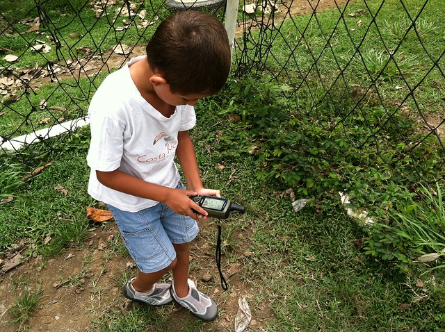
Escuela Verde has about 90 students total in grades K-5. Two teachers share a grade teaching different subjects, with half the subjects in English and the other half in Spanish. During two months, the teachers at Escuela Verde integrated several geospatial activities into their classrooms. Margarita, the social studies teacher for grades 3, 4 and 5 was the first to use GPS. Her 3rd grade class took a field trip to the local National Wildlife Refuge, Hacienda Barú, to learn about ecosystems and wildlife of Costa Rica. Hacienda Barú has over 330 hectares (815 acres) of different habitats ranging from wetlands and secondary rainforests in the lowlands to primary rainforest on the highland coastal ridge. Students hiked a portion of the seven kilometers of trails using GPS units to record observations and take photos of animals they encountered. Students recorded sightings of parrots, caimans, snakes, leaf-cutter ants, fire ants, in addition to a variety of trees.
Without electricity in the school, Margarita utilized Internet and electricity off site to learn how to download students’ data to ArcGIS online while also linking their photos. When the electricity returns, the students will download their data and link their photos to their points using ArcGIS Online.
Based on the excitement of students using GPS at Hacienda Barú, Margarita decided to engage her 4th grade mathematics class in a geocaching adventure on school grounds. Marking five locations ahead of time, she placed mathematical questions at each waypoint. Students had to answer the mathematical question before using the GPS unit to navigate to the next question.
Another teacher, David, engaged his 1st grade students’ in two activities: understanding continents and exploring rivers and mountains of Costa Rica. Seeing the value in using GIS to engage his students in having a better understanding of the world around them and not wanting to let a lack of Internet prevent him from using GIS with his students, David opted to learn to use ArcGIS for Desktop. Working outside the school to acquire and modify data for the activities, Davide engaged students in the activities using one laptop computer with a fully charged battery. Students rotated to the laptop in groups to use ArcGIS for Desktop to answer their questions.
As the teachers at Escuela Verde began using GPS and GIS in their classrooms, word started to make its way around school among students, and teachers, about the cool things they were doing in class. The teachers at Escuela Verde have shown that it doesn’t matter what resources you have, or don’t have, geospatial technologies can be used to increase students’ interest in content subject matter while making activities enjoyable for students. No electricity. No Internet. No problem. Just fully charge your laptop at home, think about the resources you have and prepare to venture down a bumpy road. The back of the school bus was always fun when it hit a few bumps in the road, right?
Yesterday I spent the day with Margarita and her 3 grade class at Hacienda Barú. Hacienda Barú is a National Wildlife Refuge situated on the Southern Pacific Coast north of Uvita. Hacienda Barú has 330 hectares (815 acres) of different habitats, from wetlands and secondary rainforests in the lowlands to primary rainforest on the highland coastal ridge.
Our trip yesterday was to walk some of the seven kilometers of walking trails with a guide to learn about the ecosystems and wildlife we encountered. Besides just walking and learning, the students worked in groups of 2 or 3 to use GPS to map locations of interest. Items of interest included parrots, caimans, snakes, leaf-cutter ants, fire ants, and a variety of trees. We also walked through the orchid garden and butterfly garden.
The next step will be to take the GPS points and download them to the computer. We will then also link the photographs to the waypoints. However, one thing that will make this step more interesting is that the school had their electricity line stolen the night before. It’s made of copper. Not sure when the electricity will get turned back on, but hopefully soon. Otherwise, we’ll make do by using a laptop that has a strong battery life.


