Venturing through the forest with Escuela Verde

Yesterday I spent the day with Margarita and her 3 grade class at Hacienda Barú. Hacienda Barú is a National Wildlife Refuge situated on the Southern Pacific Coast north of Uvita. Hacienda Barú has 330 hectares (815 acres) of different habitats, from wetlands and secondary rainforests in the lowlands to primary rainforest on the highland coastal ridge.

Our trip yesterday was to walk some of the seven kilometers of walking trails with a guide to learn about the ecosystems and wildlife we encountered. Besides just walking and learning, the students worked in groups of 2 or 3 to use GPS to map locations of interest. Items of interest included parrots, caimans, snakes, leaf-cutter ants, fire ants, and a variety of trees. We also walked through the orchid garden and butterfly garden.

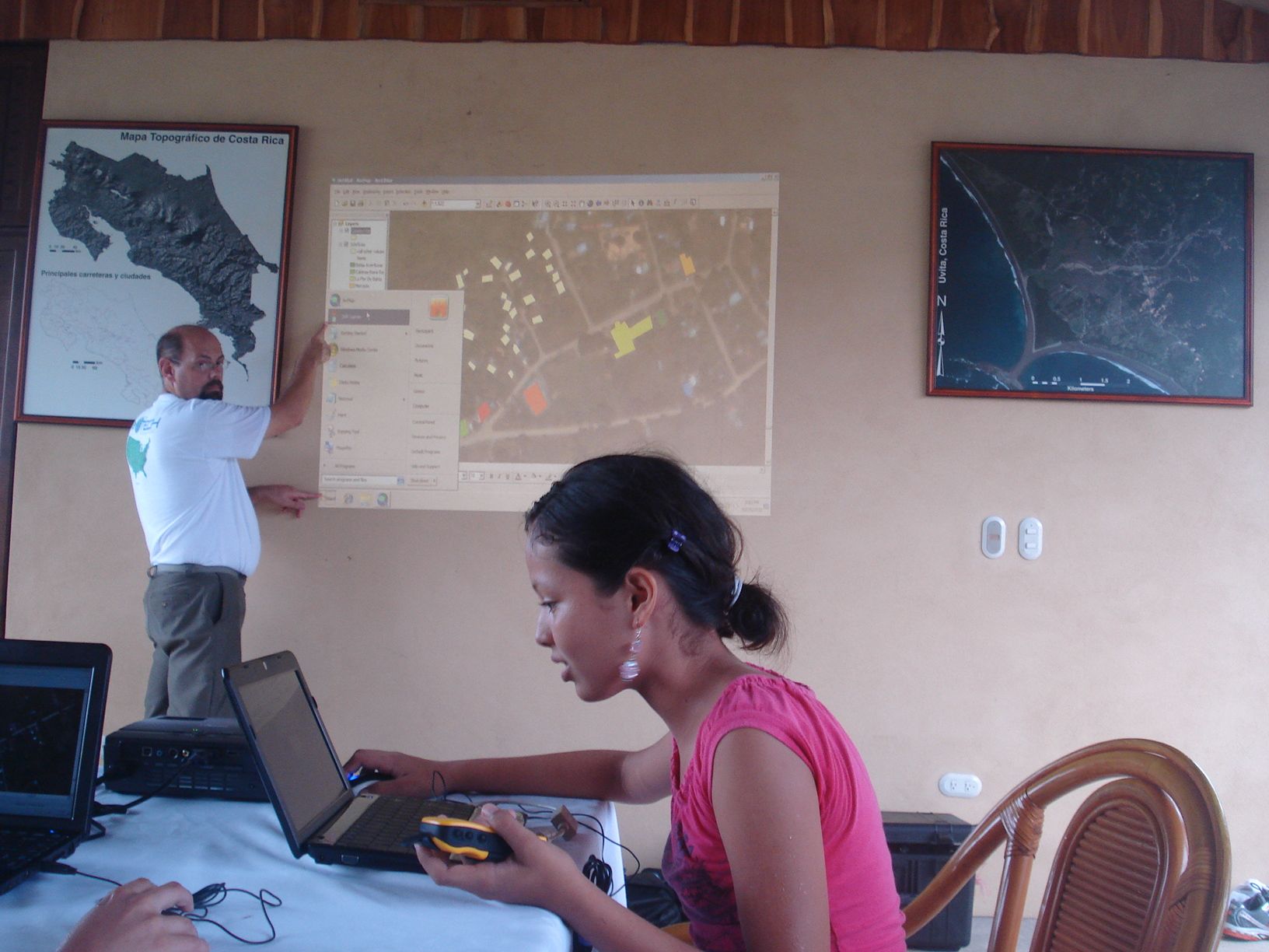
The next step will be to take the GPS points and download them to the computer. We will then also link the photographs to the waypoints. However, one thing that will make this step more interesting is that the school had their electricity line stolen the night before. It’s made of copper. Not sure when the electricity will get turned back on, but hopefully soon. Otherwise, we’ll make do by using a laptop that has a strong battery life.


Finding my way via Basura

As mentioned earlier, one of the projects I’ll be working on while I’m here Uvita – Bahia Ballena is mapping the basura (trash). The first day I arrived, I wanted to get to know my way around town a little better. I figured what better way to get to know the town than to walk around while also getting a closer look at one of the projects I’ll be working on. I could have ventured by myself, but then what fun would that be. Maria Paula was out of school for the week (think more like a spring break for students in the U.S). so she came with me. For this first venture, we walked through town and then along la playa Chaman. For this adventure we took two GPS’s. We found several other items of interest besides trash.

On our next outing the following day, Maria Paula and I stopped to pick up her friend and classmate Suhel. This time we had 3 GPS’s and a plastic bag to collect trash in. When we reached the park entrance, the park rangers let us in without having to pay the $6 that’s typically required to access the Marino Ballena National Park. We ventured in the opposite direction towards the Tombolo, or the part of the beach that look’s like a whale’s tale. This tombolo is a natural formation.

uvita-bahiaballena-whales-tale

Shortly after we ventured down the beach, we realized that the bag we brought with us to collect the trash was too small. We made too and eventually wound us using our hands to take the trash out with us. It’s amazing the type of basura you’ll find on the beach. These are some of the most beautiful beaches I’ve seen. So where does this trash come from that ends up on the beach? Well that’s one of the questions we hope that using GPS and GIS will help us to understand.


Pura Vida from Costa Rica

You know it’s been a good couple of days when you lose track of exactly what day of the week it is. My trip down from San Jose to Uvita and Bahia Ballena was wonderful. I met two other travelers, Adam and Myrna, from D.C. who were planned to spend some time down in Drake Bay. The conversation we had made the ride go by quickly. When I arrived in Bahia Ballena, I encountered a small problem. There was a slight mix up in the confirmation of my payment for the ride. I had some help from Bahia Aventuras to sort out the situation.


I’m living with Ronald, Sugey, and their kids Maria Paula, Ronaldo, and Natalia. They have been wonderful to me and I feel at home. They provided me with a little dresser to put my things in so I’m not living out of my bags, have made incredible meals and provided me with a comfortable bed. I like having a roommate again, this time Maria Paula is my roommate.

The last few days have been busy on the GEOPORT project too. I’ve met with Travis and Ronald to discuss some the projects that we would like to complete. Each project will have some different tasks to complete, but it’s a good start. The projects involve working with:

  • The tour boat operators and mapping the ballenas (whales) in the ocean. Four tour boat companies have interest. They are Bahia Aventuras, Pelican Tours, Dolphin Tours and Pacific Whales and Kayak Tours.
  • Ronald, Rafa and other community residents to map basura (trash) in the community. This will involve selecting sections of the town and working with the youth and adults to organize some mapping and trash collection events. Where is the trash found and where does it end up?
  • The school in town and working with 5th graders to map trash on football field, the salon communal (common community meeting area) and the park. There’s a new director at the school so we’ll see if there’s interest in not only mapping the trash but also doing other GPS activities.
  • Escuela Verde and the teachers to get students using GPS and GIS. In July when we were down here for the first time, we conducted a training with the teachers. So we’ll see what questions they have.

After organizing all the equipment that I brought down (computers, a projector, GPS units and a camera) for the project, I had to unload and setup everything. I had a lovely office to do this in. It’s the backyard of Travis and Pili, the neighbors of Ronald and Sugey. I’ll also be living with them while I’m down here. I think this is going to become a common office environment. I think I have a few places in town that I’ll making my working area while I’m here.


A young girl and a motivated community

uvita-bahia-ballena-maria-rogSo who is that amazing young woman in the picture above? Her name is Maria Paula and she is a fourteen year old Costa Rican student who has been captivated by GIS, GPS and its uses in her community. She is the expert of her small tourist community in mapping the trash and is using that data to help figure out ways to solve that important environmental issue. When Maria Paula was just thirteen, she gave a stunning talk on this topic to 700 GIS professionals at the Latin American GIS Conference in the fall of 2011. Please view the short video for a glimpse of the slide show and amazing talk that Maria Paula presented.

So why does GISetc care about this story? As some of you may know, Roger and I are principals of GISetc and have been traveling to Uvita-Bahia Ballena, Costa Rica over the past three years. Roger, our friend Charlie and I have been providing training to community members in the use of geospatial technologies (Esri GIS desktop and online software, GPS, remote sensing) to solve community issues. GISetc has fallen in love with the residents of Bahia Ballena and the area and are so impressed by their hard work and dedication to the environment and to each other. In response to a request from the community, GISetc is pleased to announce the inauguration of a program entitled GEOPORT (Geospatial Educators Opportunities for Partnership, Outreach, Research, and Training).

We are all looking forward to providing lots of video, images and interesting blog content on this website so come back often. Will you also perhaps consider partnering with GEOPORT and the residents of Uvita-Bahia Ballena? It will be great fun and a perfect way to connect with an international community! The GEOPORTer project is funded primarily by donations. We have some great sponsorship appreciation gifts and the opportunity to interact with the Amy Work, the first GEOPORTer while she is deployed. No amount is too small. Please share this with your family and friends. GEOPORT is a project where everybody wins!

Anita & Roger Palmer GISetc

P.S. Oh yes, by the way, please LIKE GEOPORTers on Facebook and follow GEOPORTers on Twitter.

In a bilingual school, GIS and GPS are a common language

We had our first GPS and GIS training of the week at Escuela Verde. While the students were on their two week break, a few of the teachers came back to school to see what GPS is all about and get some ideas on how they can use it in their classes. Escuela Verde is a bilingual school, offering classes in both Spanish and English for students in K-6. Some teachers were very comfortable in English, while others were native Spanish speakers with limited English. But when teaching others to use GIS and GPS, its seems that it has its own language that is universal.

Image
We started off with an overview of ArcGIS.com, demonstrating how to access a variety of basemaps and other data hosted online. One teacher, David, picked up on using the ArcGIS online immediately and had set up an account and was on his way just after the overview. It was so great to see him and the others dive right in. After some exploring on the computers we stepped outside to use the GPS units.

Image
The best way to learn how to use a GPS unit, start using the unit as you walk around the school building looking at your track and collecting waypoints. There are also several great activities that explore latitude and longitude, as well as finding your location from the Going Places with GPS book.

Image

Image

Image
Over the next month, the teachers have been asked to explore some more with the online GIS and the GPS units so that when I’m back in August I can help them answer any questions they might have as well as help them with their ideas on integrating both into their teaching.

Image

El Parque Nacional Marino Ballena

A brief stroll down the newly paved road in Bahia Ballena took us to the entrance of Parque Nacional Marino Ballena. Stopping to pick up towels along the way, we were all set to head to the beach. I must say, it was simply amazing. The water was like bath water, the backdrop of the beach were palms and forest, and blue sky’s were plentiful.

After some time at the beach, we made our way back to our hotel, La Fiore de Bahia, to cut up some piña, and make guacamole. This afternoon we met with a few people, Travis, Rafa, Ronald, y Ray, who we will be working with this time and when I come back in August. We also planned out our itinerary for the week which includes a visit to Escuela Verde to do some GPS training with the teachers, going out on a boat tour with Rafa from Bahia Aventures to get a better understanding of the whale monitoring the tour boat operators wish to do, a meeting with a few of the local boat tour guides, meeting with the KETO foundation to see what program they are working for monitoring whales, and a few other activities before we head back to San Jose Thursday.

20120701-064820.jpg

20120701-065044.jpg

20120701-071451.jpg

20120701-071559.jpg

20120701-071658.jpg

20120701-071747.jpg

20120701-071814.jpg

20120701-071951.jpg

20120701-072023.jpg

20120701-071910.jpg

Crocs and Cows: An Adventurous Ride

I arrived on time with my luggage in hand! A much different story from India. After arriving at the hotel our group met up at the local chicken restaurant, which was past Denny’s and the beyond the entrance to the Casino. After a good night of sleep, a hearty breakfast of stuffed tortillas, huevos (eggs), and fresh pineapple and papaya, Roger and Anita picked up our van, or small autobus. We then started off on our ride to Bahia Ballena, a trip that would be full of adventures.

It wasn’t long before we were heading North. We should have been heading West and Southwest. After about 40 minutes on driving, we turned around to head back to the airport, and then took the back roads through a few towns. Eventually we found the road we needed to travel down through the river valley and out to the Pacific. We eventually reached the Pacific Ocean and our first destination, a boat ride with Crocodile Man Tour.

What would a boat ride be to see crocodiles without someone getting in the water with them? Without an ounce of fear in his blood, our tour guide Jason kicked off his saddles and hopped into the muck and mud of the brackish water. With a few pieces of raw chicken, theses crocs had no reservations about getting closer to claim their treat, whether it was going to be man or chicken. Luckily the chickens won, or lost, deepening on whose side your on.

In addition to the crocodiles, there were a variety of birds, black and green iguanas, and some Jesus Christ lizards. On our way out of  Tarcoles during the afternoon rain, we passed a field of cows who were quite content.

After watching crocodiles eat, it was time for us to eat some food before we continued our drive to Bahia Ballena.

Costa Rica and Lake Michigan: What do they have in Common?

And I’m off! This time to Costa Rica. I’m traveling with Roger and Anita Palmer of GISetc for the initial trip of the GEOPORT program. During this trip, Roger and Anita will introduce me to the community they have been working with for the past 2 years. Bahia Ballena is a community of approximately 1,000 residents on the Pacific Coast of Costa Rica. During this time I will be working with a school and community membersof Bahia Ballena supporting them using GIS and GPS to examine local community issues. After this trip, I’ll head back down in August to continue working with the community for a month.

In an attempt to have a better understanding of Costa Rica and the community I will be living in, I found this list of interesting facts from Bahia Aventuras, one of the groups I will be working with.

  • Costa Rica hosts more than 5% of the world’s biodiversity even though its landmass only takes up .03% of the planets surface.
  • Costa Rica’s marine area reaches 580,000 km2, approximately 10 times larger than its land area of only 52,100 km2.
  • The staples of the Costa Rican diet are rice and black beans, along with bread, chicken or meat, vegetables, salads, and fruits.  Rice and beans mixed together for breakfast is called GALLO PINTO.
  • The average wage laborer is about $10 per day, the highest in Central America.
  • Costa Ricans refer to themsleves as “Ticos” (males) and “Ticas” (females).  Foreigners are often called “Gringos” (males) and “Gringas” (females).
  • Less than 1% of Costa Ricans are of indigenous ancestry.  94% are of European or mestizo ethnicity.
  • There are 801 miles of coastline in Costa Rica.
  • Costa Rica is divided into seven provinces; San Jose, Alajuela, Heredia, Cartago, Guanacaste, Puntarenas, and Limon.
  • There are more than 121 volcanic formations in Costa Rica, and seven of them are active.  Poas Volcano has the second widest crater in the world and Arenal is one of the ten most active volcanoes in the world.
  • Though Costa Rica has its own currency (the Colon), many stores list prices in terms of US$.
  • There are about 52 species of hummingbirds in Costa Rica, making Costa Rica a true hummingbird capital.
  • Monkeys are one of the most common mammals in Costa Rica – next to bats.  The four common species are the Howler, Spider, White-Faced and Squirrel.
  • Bug-phobist look out!  There are about 750,000 species of insects that live in Costa Rica, including about 20,000 different types of spiders!  Also, more than 10% of the worlds butterflies live here.
  • Costa Rica is one of the most valued environmental destinations.  Approximately 25% of the country has protected forests and reserves.  There are more than 100 different protected areas to visit.
  • Costa Rica has a population of 4.1 million.  The capital is San Jose, with a metro area population of approximately 2 million.  The life expectancy is almost 77 years, one of the highest in the world.
  • Costa Rica (slightly smaller than Lake Michigan) is in Central America, bordered by Nicaragua on the north and Panama on the south, the Pacific Ocean on the West, and the Carribean Sea on the East.
  • The Costa Rican government is democratic, with presedential elections every 4 years, and no standing army.
  • Costa Rican president Oscar Arias won the nobel Peace Prize for his regional peace plan.