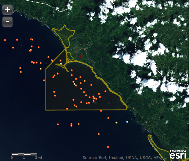
Geoporter has been lucky enough to have it’s first volunteer. Margaret Wenzlau, from Stanford University, will be here in Bahia Ballena for 1 month. Arriving July 13 she will assist in the various Geoporter projects. These projects include Mapping for Trash Elimination, Monitoring Whales in Marino Ballena National Park, and helping to get a new project off the ground that will involve recording animals killed on the Costanera, between Hacienda Baru in Dominical, and Playa Ballena, just south of Bahia-Uvita. We’ve invited Maggy to share some of her experiences here on our blog. We are excited to have Maggy here with us in Bahia Ballena and share with all of you some of the exciting this from her perspective!
Making headlines in La Nacion, a national newspaper in Costa Rica
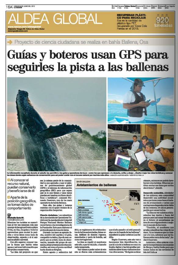
Three weeks ago, 3 of us from Geoporter took a trip to San Jose, a 3.5 hour car ride to meet with a reporter from La Nación, a national newspaper in Costa Rica to talk about the Geoporter Program and the projects we are working on here. Saturday, June 8, (which happened to also be World Oceans Day) an article came out in La Nación about one of the Geoporter projects: Monitoring Whales in Marino Ballena National Park.
Today, Monday, we are starting a series of three workshops to prepare additional guides and captains how to use GPS for monitoring whales in this project.
We are stoked about this article and one of the key things to remember is that the guides and captains in Bahía Ballena are the ones recording the observations and making the maps! What a great group of individuals to work with and
Here’s a link to the article: http://www.nacion.com/2013-06-08/Guias-y-boteros-usan-GPS-para-seguirles-la-pista-a-las-ballenas-en-Osa.aspx#formulario_encabezado
Geoporter in April
Since August of 2012, I have been living and working in Bahia Ballena, Costa Rica teaching and training educators, youth and community members how to use geospatial technologies, or GIS and GPS, to investigate their community resources or issues they think are important. I want to take just a few minutes to summarize some of the incredible Geoporter activities taking place here in this wonderful community that have occurred in the past month. There are so many things, but I’ll try to keep it short.
Pollination Project
Geoporters was selected as a recipient of a Pollination Project to improve our mobile geospatial technology lab. With their support we were able to secure a few additional GPS units, one that have a stronger signal under the forest canopy cover, two laptops to conduct additional GIS trainings, and rechargeable batteries to use with the GPS units. We are so happy to be a part of this wonderful opportunity. We have also been asked to help another Pollination Project to use geospatial technologies to map the trees they are planting. What a great example of being able to thank The Pollination Project by “paying it forward.”
Let’s talk about Boundaries and Mountains at Escuela Verde:
I’ve had the opportunity to work with incredible teachers and staff at Escuela Verde, a bi-lingual school for grades K-6. To see the way these students are processing the information related to the GPS and GIS activities they are doing, is incredible. The past few weeks I have been working closely with Esteban, the new 5/6th grade science teacher and David, the 1st/2nd grade social studies.
David’s students are learning about political boundaries and key features found in every Costa Rican town; which include a soccer field (cancha), mini-supermarket (pulpería), church (iglesia), and school (escuela). To make learning these concepts more fun, we took a field trip to actually see the boundaries of the district, Costa Ballena, where the school is located. We marked the locations of the boundary limits and the features using GPS units. Oh, and don’t forget about the photos to go along with GPS’ing the locations.
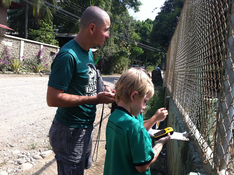
The class is now downloading the waypoints and photos, and transferring the information that was recorded on paper to a digital version so we can symbolize the features to create a map to share with their parents.
Esteban’s 5/6th grade class has been exploring mountains, valleys, rivers and deserts that are found in Costa Rica and around the world (with deserts in the world rather than Costa Rica). What is the tallest mountain in the world? What is the largest desert in the world? The longest river? And where are all of these features located?
After examining a map of these features using ArcGIS Desktop and a modified activity from Mapping Our World, we used GPS units to mark elevations on school grounds. The students were able to compare mountains, valleys and rivers found on the map, but understanding differences in elevation. Next students are planning to create presentations highlighting these features and more information about each theme.
What to do when the northern whales have started their migration north?
The whale monitoring project working with tour guides, captains and tour companies has taken somewhat of a break this month due to the early departure of the northern whales that have called Bahia Ballena home since late October. But this has provided us the opportunity to prepare for the southern whale migration season, which will arrive in June and stay through early November.
We are in the process of mapping the whale sighting data from this past season of northern whales to add to the map of the southern 2012 whale season from August to October. We will then be able to use these maps when we start our training for new guides and captains next week.
Rise and shine!!! It’s Trash Collection Time!!
Starting in April, a solid group of about 8 people (at times up to 15 people) have collected and categorized trash in order to map the landscape of trash in the streets and on the beaches of Bahia Ballena. We’ve had 5 trash collections starting at 6 am. Yep, that’s 6 am. The sun has just come up and it’s one of the coolest times of the day. We’ll collect trash until 8 am, but it seems that we have such a great group that we don’t finish until around 9 am. And one day, we went until 10 am when the sun and heat let us know that it was time to call it a day.
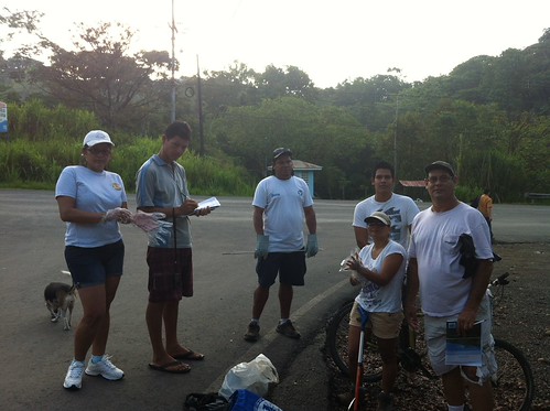
We’ll continue to map the trash in the streets to continue providing information for others, Asociacion de Guias de Bahia Ballena (ASOGUIBA), Asociacion de Tour Operadores, and the Asociacion de Desarrollo (Development) can construct new trash cans and place them in the areas of trash hotspots.
Silence your cell phones, it’s presentation time
On May 7th, Geoporter had the opportunity to present our project and what we are doing to the Chamber of Tourism and Commerce of Costa Ballena de Osa (CACOBA). We presented all the projects we have been working on and a future project of creating a community map of Bahia Ballena with youth here in town. We’ve already made some progress with getting some of the waypoints and photos of different tour companies, restaurants, hotels in town.
We were also invited to a meeting organized by KETO to present our trash mapping project as they continue to work with different individuals, organizations and the National Park staff to seek improvements for Marino Ballena National Park.
This week, we will be driving to San Jose to make a presentation to La Nacion, a national newspaper in Costa Rica. In the afternoon we are headed over to meet with MarViva, an organization that promotes the conservation and sustainable use of coastal and marine ecosystems in the Eastern Tropical Pacific.
Basura en las costas del mundo
Les invitamos a leer este interesante articulo sobre la basura que es arrastrada o tirada en las costas del mundo. A todos esos que han colaborado con el proyecto del mapeo de basura de las calles de bahia ballena les decimos son unos valientes que merecen una medalla de honor porque ademas de evitar que toda esa basura sea arrastrada al mar y hacer la isla de basura cada dia mas grande han quizas salvado muchas tortugas,peces,aves,cetaceos y muchas otras especies que habrian sido victimas de esa basura.
http://www.tribuglobal.com/index.php/geografia/mares/619-619.html
Agradecemos a GEOPORTER y en especial a Amy Work por su gran aporte a nuestra comunidad. Luz Mirian Badilla,Ronald Guzman colaboradores al 100% en este proyecto.
Aprovechamos para invitar a los Hoteles de la zona a que conoscan este proyecto y se involucren con estas iniciativas que benefician a todos los empresarios turisticos de la zona.
Muchas gracias
—
” THINK ABOUT THE FUTURE, THINK RESPONSIBLY “
Bahía Ballena, OSA, Costa Rica
Learning about Political Boundaries and Pueblos with Escuela Verde
Recoleccion de Basura // Trash Collection – April 5, 3013
Geoporter Map Gallery
Geoporter Program Overview
Investigating Dengue
Inspecting for dengue
This year, 2013, marks the 20th year dengue fever has had a presence in Costa Rica. In 2012, Costa Rica doubled the number of dengue cases from 2011. Thankfully, there were no deaths. With more than one-third of the world’s population living in areas at risk for transmission, dengue infection is a leading cause of illness and death in the tropics and subtropics. This global map shows that other countries with reported cases of dengue surround Costa Rica.
Here in Bahía Ballena, the Ministry of Health is doing it’s best to take preventive measures in protecting its people against dengue. I had the opportunity last week to travel around with Milton Lobo, a worker for the Ministerio de Salud for the Oso Canton, to investigate houses for possible signs of dengue. It was only the week before that I had met Milton when he came to my casita to inspect for dengue. It was at my casita that I was able to learn more about his work inspecting houses for dengue in Bahía Ballena. After explaining the Geoporter project, we set up a meting to use GPS to map the houses he is inspecting.
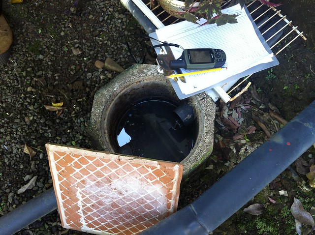
Milton is responsible for overseeing and inspecting vectors of disease transmission for a rather large area of Costa Ballena, including Bahía Ballena, Uvita, Cortes and Palmar Norte. He must travel and visit every house in the towns and inspect them for signs of dengue. The routine of visiting houses here is a bit different than in the U.S., where here, Milton doesn’t inspect the property if no one is home. Someone must be home for him to inspect the property. This makes things a bit interesting when there are several houses here in town that are seasonal houses or weekend casitas.
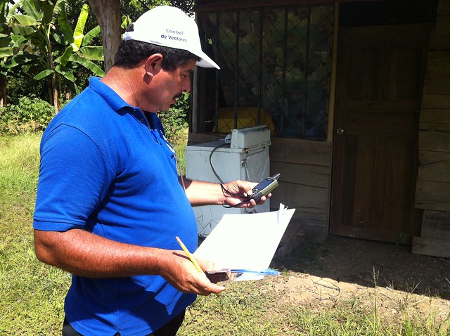
After always seeking permission from the homeowner, he works his way around the house, starting to the right. He is looking for standing water that is close to the home. Not just any standing water, but standing water in containers that have solid surfaces underneath, such as buckets, old metal containers, tires, or toilets that are no longer used in houses. The solid containers are a prime location for female mosquitos, the transmitters of dengue, to lay their eggs. Without solid surface containers to hold water the mosquitos will search elsewhere to lay their eggs.

At one house, we encountered an old toilet that had standing water. Now began the fun part, inspecting the water for mosquito eggs and larva of a specific species. There are many species of mosquitos, yet only one of concern for dengue is Aedes. Milton, who has been working this job for over 12 years said it has become much easier for him to identify those species that carry dengue and malaria. When a larva mosquito is in standing water, if it is at a 45-degree angle, it is not a carrier of dengue. However, if the mosquito is vertical in the water, and also swims in a figure 8 fashion, it is the species to transmit dengue.
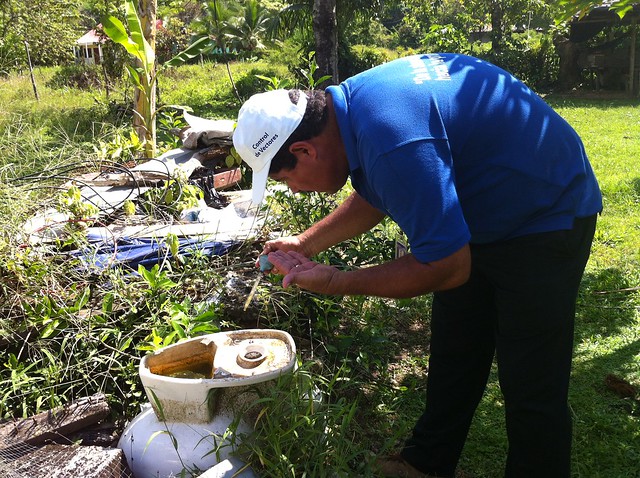
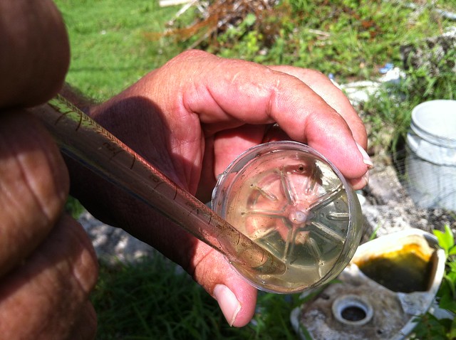
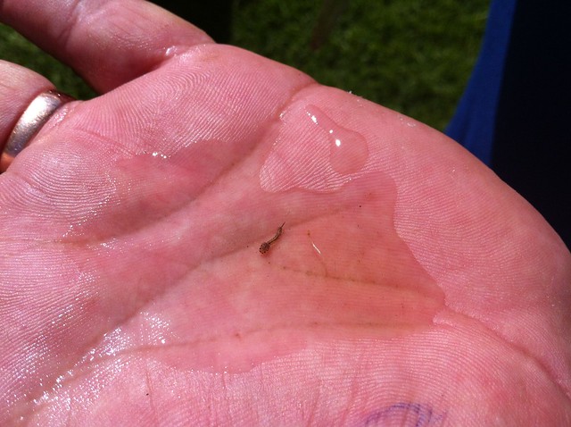
While the toilet with standing water did contain eggs and larva, the larva were angled at 45 degrees in the water and therefore not a carrier of dengue. However, to be on the safe side, ever container of standing water, Milton placed a pebble or sprinkled some powder to ensure that the water would not be a habitable environment for eggs or larva.
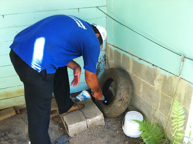
During our adventure, Milton quickly picked up GPS and mapped every house we inspected and added the waypoint number to his inspection sheet. We covered two manzanas (or blocks), but as Milton says, there are some houses that take longer to inspect. By mapping those houses that are closed and need revisited, or those that have standing water, we will be able to see if there is an area of town that has several house close together that have standing water in solid containers. The best action is preventative action.

